|
| |
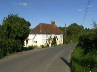 Mountfield in East Sussex is a small village lying between Battle and
Robertsbridge.
The village is mentioned in the Domesday book
"Reinbert holds Mountfield from the Court, Goda
held it before 1066 . There is enough land for 8
ploughs, 2 for the manor house, and 6 worked by 9
serfs and 2 cottagers. A further 8 acres of meadow,
and woodland for 10 pigs".
Most of the area surrounding Battle was laid to waste
by William the Conqueror 's men before the Battle of
Hastings , Mountfield was no exception, and most of
the local population were killed. Mountfield in East Sussex is a small village lying between Battle and
Robertsbridge.
The village is mentioned in the Domesday book
"Reinbert holds Mountfield from the Court, Goda
held it before 1066 . There is enough land for 8
ploughs, 2 for the manor house, and 6 worked by 9
serfs and 2 cottagers. A further 8 acres of meadow,
and woodland for 10 pigs".
Most of the area surrounding Battle was laid to waste
by William the Conqueror 's men before the Battle of
Hastings , Mountfield was no exception, and most of
the local population were killed.
In the 17th Century, the area around Mountfield
was believed to have large seams of coal deposits.
A bore hole was sunk, the engineers found no coal,
but they discovered large deposits of gypsum
(Calcium Sulphate). This material is used to
manufacture plaster, plaster of paris, plasterboard,
and cement.
A mine was set up in the woods, now known as
Limekiln Woods, and the underground workings spread
for a wide area under the Sussex landscape. Since
then, a large manufacturing plant has been set up,
and is hidden in the woodland surrounding the area,
the goods are usually shipped out via the Railway.
The only view of the factory is a plume of steam,
which climbs up from the works, and is visible from
surrounding hills. A 5 mile long conveyor belt
looking similar to a centipede, crawls across the
landscape from Mountfield to Brightling where there
is a second mine.
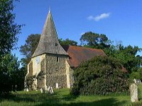
The Tapsell Gate was invented by a localcarpenter from
Mountfield in the mid 1700's. The gate was designed to
stop cattle straying into the Church Yard. It rotates
on a post, in a similar way to the design of a Post Mill .
In 1863 a farmer William Butcher was ploughing his field in the
village, when he found a number of yellow metal items. He thought
it was brass and sold it on to local ironmonger for scrap. In fact
it was gold, as the ironmonger soon discovered. Due to the law
the items would have been claimed as treasure trove, the ironmonger
melted the pieces down and sold it as bullion. There are only two small
pieces of the Mountfield Hoard left, these can be found in the British Museum.
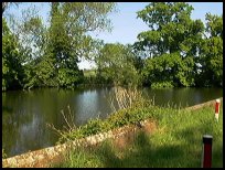
The Darwell Resevoir is found nearby via a tiny
country lane, and is a haven for fishermen, and
wild fowl. |
|
 The very best views within the Mountfield in East Sussex area are down
the Brightling road past the village duck pond, and then
further on until you see the Darwell Resevoir on your
right. The very best views within the Mountfield in East Sussex area are down
the Brightling road past the village duck pond, and then
further on until you see the Darwell Resevoir on your
right.
If you prefer tree lined secret back lanes, then take
the Netherfield road across the railway line, and into
the woods. |
|
 Mountfield in East Sussex has limited services, and to to get
anywhere a car is needed. A primary school is
located in the area known as John's Cross, after
an inn of the same name, which has provided for
travellers for many centuries. Mountfield in East Sussex has limited services, and to to get
anywhere a car is needed. A primary school is
located in the area known as John's Cross, after
an inn of the same name, which has provided for
travellers for many centuries.
The main Hawkhurst to Battle bus service stops
in Johns Cross providing a frequent service.
The nearest large town is Hastings about 7 miles
South, the smaller town of Battle approx 3 miles
South provides additional services. |
|
| Mountfield is shown as the red symbol on the map. |
|
|
Nearby Villages
(click on symbol to see the village page) |
| Village= | |
Town= | |
Recorded in Domesday= |  |
| |
|
|
Ashburnham |
(Last Iron Furnace in Sussex) | | 5.05 miles |
|
|
Battle |
(William the Conqueror prevails) | | 2.71 miles |
|
|
Bodiam |
(The finest ruined castle in the Country) | | 4.14 miles |
|
|
Bodle Street |
(White Horse on the roof) | | 6.70 miles |
|
|
Brede |
(Edward I inspects the Channel Fleet) | | 5.32 miles |
|
|
Brightling |
(famous for Mad Jack Fuller) | | 3.58 miles |
|
|
Broad Oak Brede |
(On the Crossroads) | | 5.18 miles |
|
|
Burwash |
(The home of Rudyard Kipling) | | 4.98 miles |
|
|
Burwash Common |
(Roughest pub in the South East) | | 6.37 miles |
|
|
Burwash Weald |
(Roughest pub in the South East) | | 5.97 miles |
|
|
Cripps Corner |
(Home Guard surprises the Army) | | 2.16 miles |
|
|
Dallington |
(Custers Last Stand!) | | 5.39 miles |
|
|
Etchingham |
(The oldest Brass Weather Vane in the country) | | 4.08 miles |
|
|
Ewhurst Green |
(Great Fire of London contributions) | | 4.12 miles |
|
|
Guestling |
(Changing guards at Buckingham Palace) | | 7.59 miles |
|
|
Netherfield |
(Village at the top of the Hill) | | 2.29 miles |
|
|
Northiam |
(Prime Ministers D Day inspection) | | 5.88 miles |
|
|
Penhurst |
(Beautiful yet Remote) | | 3.88 miles |
|
|
Robertsbridge |
(The Home of Modern Cricket) | | 2.06 miles |
|
|
Salehurst |
(Richard the Lion Heart's Gift) | | 2.52 miles |
|
|
Sedlescombe |
(Best gunpowder in Europe) | | 2.84 miles |
|
|
Staplecross |
(Mothers grudge hangs son) | | 2.74 miles |
|
|
Westfield |
(Bonfire Boys under suspicion) | | 5.29 miles |
|
|
Whatlington |
(King Harold's Manor) | | 1.68 miles |
|
|


